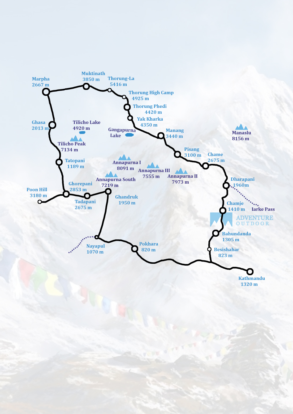
Annapurna circuit trek - 22 Days

/ Person

Trip Highlights

  • estination: Annapurna Circuit (5416 m)
  • Group Size: min 1
  • Max. Altitude: 5416 m
  • Grade: Strenuous
  • Season: February to Mid-June, September – November
  • Accommodation: Tea House.
  • Transportation: Tourist Bus, Private Car/Van, Plane.
  • Entry: Besisahar
  • Exit: Pokhara

Trip Overview

Annapurna Circuit Trek: An Immersive Himalayan Adventure

The Annapurna Circuit Trek is one of Nepal's classic trekking routes, taking you through a remarkable diversity of landscapes – from lush green paddy fields and subtropical rainforests to deep valleys, snow-capped slopes, and a semi-arid Tibetan-like terrain. The highlight of the trek is the Thorung La Pass, standing tall at an elevation of 5,416 meters (17,769 feet).

The trek spans across four regions – Lamjung, Manang, Mustang, and Myagdi, offering a captivating blend of cultures and traditions. In the lower regions, you'll experience Hindu influences, while ascending to higher altitudes unveils a rich tapestry of Buddhist cultures, including Sherpa, Tibetan, and the unique Gurung traditions.

Trekking Highlights:

  • Diverse landscapes: From verdant valleys to arid deserts
  • Crossing the world's deepest gorge, the Kali Gandaki
  • Encountering diverse flora and fauna, including 101 mammal species, 478 bird species, 41 reptile species, and 23 land and water animal species
  • Exploring the Annapurna Himalayan range's towering peaks
  • Immersing in the cultural richness of Hindu and Buddhist traditions

The Annapurna Circuit Trek is a true feast for the senses, offering an unparalleled trekking experience that combines breathtaking natural beauty with a deep dive into the region's diverse cultural heritage.

Trip Itinerary

Expand all
day1

Arrive in TIA, Kathmandu

Our representative will pick you up at the airport. Get a feel for the streets the first day, absorb the sights and sounds, or rest at the hotel. We discuss the journey in the evening.

day 2

Namaste Kathmandu

Kathmandu, the capital city, boasts an intense mix of cultures and religions unique to Nepal. Turn the Buddhist prayer wheels at Swoyambhu- the monkey temple and meet the steady gaze of the Buddha’s eyes at the famous Boudhanath stupa. Experience the valley’s olden days at the Kathmandu Durbar Square- which has remained authentic even as modernization has crept in all around it. See Kathmandu, with our trained guide. (or skip this and drive to Besisahar)

day 3

Drive from Kathmandu to Besisahar (823m)

You drive along the Kathmandu-Pokhara Highway to Dumre and then follow the narrow road along with Marshyangdi River to Beshisahar, the locale central of Lamjung region. All the nearby government workplaces are arranged here. From here, you can see some mountain tops, regular views encompassing the valley and the everyday activities of people there. This base camp is the middle from where the everyday usable items are provided to the distinctive towns and various towns. Stay night at hotel/lodge.

day 4

Trek from Beshishahar to Bahundanda (1305m)

The initial segment of the trail passes on a level along the bank of the Marshyangdi stream. You can appreciate the views and the nearby culture of Gurung people . After lunch the trail goes steeply upwards to Bahundanda which takes around 2 hours. Starting here, you can see the region encompassed by eye-getting situations with snow - topped mountains. Stay night at hotel/lodge.

day 5

Trek from Bahundanda to Chamje (1410 m)

A precarious trail dives for early 30 minutes and afterward finishes a level way rice porch before intersection a stream at the base of a little cascade. It at that point climbs again and navigates the slope high over the stream before achieving the town of Lali Gaon. Ahead the Marshyangdi valley frames a precarious V-shape and you take after the winding mountain way down through Syange (1100m) where there is a delightful cascade above and along the stream for some separation. The trail at that point climbs steeply and the way is cut into the sheer bluff face some 200-300m over the riverbed. In the long run you plunge to the stone town of Jagat (1330m) arranged on a rack that extends into the steep Marshyangdi valley. Stay night at hotel/lodge.

day 6

Trek from Chamje (1410m) to Dharapani (1960m)

The initial segment of the trail plunges to the waterway and subsequent to intersection a suspension bridge connects, you start a move to Sattale (1550m) on a way so steep that it appears to be one slip would send you tearing down into the valley. You proceed on an undulating way over the stream, and at a certain point, where a tributary stream in from the contrary bank, the principle waterway winds up secured with gigantic rocks that conceal the water. Climbing the crisscross way to the highest point of the slope, you see the level, plain of Tal (1700m). Although it is encased by precipices, the level zone looks consoling after the nerve racking mountain ways simply went on. You dive to a lush stream bank that prompts Tal with its lodgings and tea houses. Here you can appreciate the invigorating cascades. Past Tal, the valley limits and the way turns out to be high and twisting and, in a few regions, slashed from the stone itself. Past the little town of Karte (1900m), there is more precipice strolling before the way drops again to the stream. You cross a suspension extension and climb the short separation to the stone Mani denoting the passage to Dharapani (1960m), and your camp for the night. Stay night at hotel/lodge.

day 7

Trek from Dharapani to Chame (2675m.)

You move through woodlands of pine and oak as you go through Danaque (2210m). Before long, there comes a little wooden extension that will take you on a steeply rising way up to Timang which lies at the base of Lamjung Himal. The trail goes then on a level until the point when you achieve Chame, where you will discover government workplaces, shops and inns. Chame is the managerial base camp for the Manang region. Stay night at hotel/lodge.

day 8

Trek from Chame to Pisang (3100m) takes around five hours.

With Lamjung Himal (6893m) shining toward the beginning of the day sun, you set off for Pisang. You proceed through some fir and pine backwoods, moving to a high, rough region as the contrary bank turns into a blocked bluff. Starting here the valley turns out to be to a great degree soak sided as you take after the way to Bhratang (2950m). You presently stroll through a pine woodland and as the timberland closes, the valley changes from a V-shape to a delicate U-shape, opening a great vista before you. You can see the east pinnacle of Annapurna II and Pisang Peak (6091m) toward the north-east. Proceeding on, you go to a long Mani divider by an extension and the lower town of Pisang. Stay night at hotel/lodge.

day 9

Trek from Pisang to Manang (3440m)

Past Pisang, the trail climbs a lofty edge that manages great perspectives of the Manang valley and Tilicho top (7145m). Plummeting past Manang's airstrip at Hungde (3320m), you go to a level region from where the north-east face of Annapurna III transcends you. From the wide fields of the Sabje Khola Valley, Annapurna IV (7525m) likewise ends up noticeable. Just past this point you cross the extensively lessened stream of the Marshyangdi Khola by means of a wooden scaffold to the modest town of Mungji. After a short soak climb you achieve Manang which is a shockingly expansive town for this remote mountain locale. Stay night at hotel/lodge.

day 10

Acclimatization Day

This is an essential rest and acclimatization day today before intersection the Thorong La. There are discretionary day strolls, for example, crossing the stream to see the colossal icefall descending from the Annapurnas, or moving high over the town for a full scene of the Annapurna run and the Manang Valley or you can visit Ganagapurna Glacier Lake to make your rest day an essential one. Stay night at hotel/lodge.

day 11

Trek from Manang to Yak Kharka (4350m).

Presently the trail climbs delicately the distance to Yak Kharka going through Gunsang (3960m.) town. In transit, you see all encompassing perspectives throughout the day. Stay night at hotel/lodge.

day 12

Trek from Yak Kharka to Thorong Phedi (4420m)

Leaving Yak Kharka, you climb continuously to an edge before dropping to the headwaters of the Marshyangdi and intersection by means of a secured wooden scaffold. After a short climb up the mountain way on the correct bank, you take after a limited trail over an unsteady binge incline and after that slide to Thorong Phedi. Stay night at hotel/lodge.

day 13

Trek from Thorong Phedi to Muktinath (3850m) by means of Thorong La (5416m) Pass

You begin early today for your intersection of Thorong La (5416m). The perspectives are emotional without a doubt, from the snow-secured mountains above, to the top of the Kali Gandaki valley underneath and the dark colored and purple slopes of Mustang which are spread out before you. In the end the moraines offer approach to verdant slants previously a charming stroll along the Jhong Khola Valley to Muktinath and its shrines and temples. Stay night at hotel/lodge.

day 14

Trek Muktinath to Marpha (2667m)

You currently start the drop down the sensational Kali Gandaki Gorge, at first through bone-dry nation in indistinguishable land and climatic zone from Tibet. After going through Jharkot and Khingar towns with normal Tibetan architecture, you take after the valley floor almost the entire way to Jomsom. From here there are fine perspectives of the Nilgiri crests. You keep strolling down to Marpha, a great Thakali town, finish with a waste framework underneath the flagstone avenues. Its limited back streets and ways give welcome asylum from the solid breezes of the Kali Gandaki Gorge. Stay night at hotel/lodge.

day 15

Trek from Marpha to Ghasa (2013m)

Your trail plummets steeply through woodlands to Ghasa, the last Thakali town and the southern-most point of confinement of Tibetan Buddhism. The starting piece of the trail is extended at just about a level to Kalopani and afterward your trail starts slipping steeply to Ghasa. The initial segment of the trek goes through the blustery region secured with pine backwoods, rhododendron woodlands and birches.The encompassing territory of Ghasa is a well-known goal for winged animal viewing and wild Marijuana. Here you are very astounded at the all-encompassing perspective of Mount Nilgiri North (7061m), Nilgiri Central (6940m), and Nilgiri South (6839m), Annapurna I (8091m), Dhaulagiri I (8167m.) and Tukuche crest (6920m) Stay medium-term at hold up.

day 16

Trek from Ghasa to Tatopani (1189 m.)

The trail dives steeply to Rukse Chhahara (Rukse Waterfalls). The most profound chasm of the world is arranged between the two mountains Annapurna I (8091m) and Dhaulagiri I (8167m) which confront each other close Rukse Waterfalls. Presently, the trail rises marginally to Tatopani through various human settlements. You can appreciate the hot spring at Tatopani as the word Tatopani is named after the regular hot spring arranged at the bank of the Kali Gandaki River. It is prominently trusted that scrubbing down in hot spring encourages you to dispose of skin infections. Alongside this, it gives you physical and mental refreshment too. Stay night at hotel/lodge.

day 17

A rest day at Tatopani to appreciate the common hot spring shower.

Following a few long periods of trekking, it is an awesome plan to wash up at hot spring and unwind. Stay night at hotel/lodge.

day 18

Trek from Tatopani to Ghorepani (2853 m.)

Your trail passes on a level for some separation. At that point the trail starts climbing steeply for no less than 60 minutes. The way at that point goes up through various towns possessed by the general population of various stations and agrarian land. Most of the general population here serve in the Gorkha Regiment. While trekking you cross through the Kali Gandaki stream with all-encompassing perspectives of Dhaulagiri and Annapurna ranges. Stay night at hotel/lodge.

day 19

Trek from Ghorepani to Poon Hill (3180m) to Tadapani (2675m)

Early morning outing to Poon Hill (3232m.) to appreciate the dawn see over Mt. Dhaulagiri (8167m), Tukuche Peak (6920m), Nilgiri (6940m), Varaha Shikhar (7847.), Mt. Annapurna I (8091m), Annapurna South (7219m), Annapurna III (7855m) and many more. Stay night at hotel/lodge.

day 20

Trek from Tadapani (2675m) to Ghandruk (1950m).

It is a simple trek by plummeting delicately completely through rhododendron, oak and different sorts of thick woods. You can hear various types of feathered creatures peeping in transit. This is a mainstream goal for the fowl sweethearts. Ghandruk is a major Gurung town where there is a handiwork focus and Gurung historical center. From this town you can see great perspectives of Annapurna South, Hiunchuli, Gangapurna (7455m), Annapurna III (7755m) and Fishtail. Stay night at hotel/lodge.

day 21

Trek from Ghandruk (1950m) to Nayapool

The initial segment of your trek is steeply down after a stone staircase from Ghandruk to Birethanti and then the road moves straight along the modi khola bank. Catch our vehicle at Nayapool an drive to pokhara and enjoy at lake side. Stay at hotel at night

day 22

Drive from Pokhara to Kathmandu takes around seven hours.

While driving from Pokhara to Kathmandu, you go to Damauli, Dumre, Muglin and Kurintar where Nepal's first Cable auto is worked to achieve Manakamana Temple. In transit, you can appreciate the mountain sees, green landscapes, rice porch fields, vegetable fields and individuals being occupied with their day by day life exercises. From Naubishe you move up to Thankot, the passage to Kathmandu.

What’s Included

Service Includes:

  • Airport pick-up and drop-off services by private A/C car or Van
  • Trekking guide/s
  • Porter/s (1 porter carries 20 kilograms of luggage)
  • All meals three times a day (breakfast, lunch and dinner) during the trek
  • Accommodation in tea houses (lodges) during the trek
  • Sleeping bags, down jackets, duffel bags and trekking sticks etc.
  • Entry Permit for Annapurna conservation Area
  • Trekkers' Information Management system (TIMS) card
  • All land transportation wherever applicable
  • 1-night hotel accommodation in Pokhara with breakfast
  • insurance and equipment's for the trekking staffs
  • First aid kit
  • Rescue assistance (Should any emergency arise during your trek, we will provide prompt and professional rescue and medical services. For this, it would be better to have your own travel insurance that can cover helicopter evacuation and medical treatment cost in case required.)
  • Farewell dinner
  • All tax, VAT and company service charge

Service Not included:

  • Personal nature expenses
  • Drinks, beverages, hot shower, etc.
  • Travel insurance Tips
  • Lunch and dinner in Pokhara
  • Meals and hotel accommodation in Kathmandu

Frequently Asked Questions

How fit do I need to be to do this trek?

You need to be in good physical condition and have a basic level of endurance to handle the Annapurna Circuit trek's varied terrain and high-altitude challenges over 22 days.

How long do we walk every day when doing Annapurna circuit trek?

On the Annapurna Circuit trek, you typically walk between 5 to 8 hours each day, covering distances of about 10 to 20 kilometers (6 to 12 miles) depending on the specific itinerary and acclimatization needs.

What is the highest altitude reached in this trek?

The highest altitude reached on the Annapurna Circuit trek is the Thorong La Pass, which sits at 5,416 meters (17,769 feet) above sea level.

What about battery charging and hot shower facilities?

On the Annapurna Circuit trek, battery charging and hot showers are typically available at teahouses, but may involve additional fees and vary in reliability, especially at higher altitudes.

What about internet access?

Internet access is available in many teahouses along the Annapurna Circuit, though it may be slow and come with a fee, particularly in more remote areas.

Is it necessary to hire Guides/trekking agency for the Annapurna Circuit trekking?

While it's not strictly necessary to hire a guide or trekking agency for the Annapurna Circuit trek, doing so can provide significant benefits, including local expertise, safety, and logistical support.

How much do guides and porters cost?

On the Annapurna Circuit trek, guides typically cost $20 to $30 per day and porters $15 to $25 per day, with additional fees for tips and potentially accommodations and meals.

Trip Map